This is a very useful app. It's much easier than hand writing notes when I'm using multiple cameras loaded with different film. Thanks!I can't believe it's been five months since the last update. However, today I'm happy to announce, that I've released version 1.7.0 to the Play Store and it should be available for everyone to download. Changes include:
Under the hood I have done some massive code rewriting to make the code more manageable. All in all this was the biggest update since the launch of this app.
- Bug fixes
- Special characters are now allowed when entering text anywhere in the app.
- Filters can now be added to the database and frame's information.
- Shutter speed and aperture increment are now camera and lens specific respectively instead of global settings.
- Lenses now have an aperture range, focal length range and aperture increment setting.
- Cameras now have a shutter speed range and a shutter speed increment setting.
- Rolls now have ISO, push/pull and format attributes.
- Frames now have focal length, exposure comp, no. of exposures and filter attributes.
- The user can now export and import the entire database as a .db file. This is useful when you want to transfer all your data to a new phone for example.
- Changes to ExifTool commands: file names can now have a prefix before the frame number and the user can now choose in the settings which file ending should be used.
If you have any ideas on how to improve the UI of the app, I'd be glad to hear them. For example the frame information dialog is beginning to get a bit cluttered. What do you think, should the frame settings be represented as a list instead of separate buttons? Also I've gotten some feature wishes, which I have yet to implement. And new frame settings (e.g. flash information, metering mode etc.) will be added along the way.
-
Welcome to Photrio!Registration is fast and free. Join today to unlock search, see fewer ads, and access all forum features.Click here to sign up
- Home
- Forums
- Analog Workflow Forums (100% Analog/Traditional)
- Analog Equipment
- Miscellaneous Equipment
You are using an out of date browser. It may not display this or other websites correctly.
You should upgrade or use an alternative browser.
You should upgrade or use an alternative browser.
New app for making "exif notes"
-
A
- Thread starter team_player
- Start date


Recent Classifieds
-
Want to Buy Nikon F2 black camera
- Started by ediz7531
-
Want to Buy Sekonic l-308 lumisphere
- Started by jwd722
-
For Sale Vacuseal Vacuum Press 4468H
- Started by oficinouno
-
For Sale Paper Safes and glossy photo paper
- Started by oficinouno
-
For Sale Nikon d810, RRS bracket, battery charger and 3 batteries..$800
- Started by ChrisK
Forum statistics
Ivo Stunga
Member
Hello there!
Looks like I've finally found an app that comes close to my ideas of how Film and EXIF should work together. Much respect for that! Let's start with appreciation - I really do appreciate your work and what it brings to the table. Respect!
And let's continue with some suggestions if I may:
- It's rare to change lens and keep the same filter. So, when swapping lenses, filter should reset to None?
- A field for title? Or User Comment could act like oneand show-up in Description field in Flickr, for example (same as Caption in Lightroom);
- I really would appreciate a complete Gray/Black theme. I do a lot of URBEX and the overall white would just blind me and my co-urbexers. And summon a guard or two : D
- Maybe there should be an option to combine filters defined. For example, for ultra-dramatic shot I would love to use both CPL and Red filters combined;
- And about the file naming/numbering - I really like my old filename schema and would love if there was an option to define where app should look for the frame number. My schema grants me superb sorting by year - film shot in that year, frame number of that film of that year.
For example - I name my scans like this: 17.13 - Delta 100 - 03. Subject.tif
where
17 - Year;
13 - Film shot in that year;
Delta 100 - Self Explanatory
03 - Frame Number
Subject - Self Explanatory.
So then I could keep my naming and tell the app where to look for frame number.
And different users have different naming patterns, so they could keep that habit unchanged.
And again - THANKS!
From now on - no more hassle with Google Docs and Analog Exif on the PC end, and then rewriting date again in Lightroom, as there's an incompatibility of tags or something : )
Last edited:
What a great app! Been using a notebook for this and this makes it So much easier!
Thanks!
Thanks!
Ivo Stunga
Member
And one more idea - as the frame number, date and time is defined automatically, maybe the clutter coul be reduced by making one button to edit these, which would say "Adjust date and time" or something, if such a need arises. Which can arise.
And maybe such an option could be located under the three dots thingy.
And maybe such an option could be located under the three dots thingy.
OP
OP
Hello there!
Looks like I've finally found an app that comes close to my ideas of how Film and EXIF should work together. Much respect for that! Let's start with appreciation - I really do appreciate your work and what it brings to the table. Respect!
And let's continue with some suggestions if I may:
- It's rare to change lens and keep the same filter. So, when swapping lenses, filter should reset to None?
- A field for title? Or User Comment could act like oneand show-up in Description field in Flickr, for example (same as Caption in Lightroom);
- I really would appreciate a complete Gray/Black theme. I do a lot of URBEX and the overall white would just blind me and my co-urbexers. And summon a guard or two : D
- Maybe there should be an option to combine filters defined. For example, for ultra-dramatic shot I would love to use both CPL and Red filters combined;
- And about the file naming/numbering - I really like my old filename schema and would love if there was an option to define where app should look for the frame number. My schema grants me superb sorting by year - film shot in that year, frame number of that film of that year.
For example - I name my scans like this: 17.13 - Delta 100 - 03. Subject.tif
where
17 - Year;
13 - Film shot in that year;
Delta 100 - Self Explanatory
03 - Frame Number
Subject - Self Explanatory.
So then I could keep my naming and tell the app where to look for frame number.
And different users have different naming patterns, so they could keep that habit unchanged.
And again - THANKS!
From now on - no more hassle with Google Docs and Analog Exif on the PC end, and then rewriting date again in Lightroom, as there's an incompatibility of tags or something : )
And one more idea - as the frame number, date and time is defined automatically, maybe the clutter coul be reduced by making one button to edit these, which would say "Adjust date and time" or something, if such a need arises. Which can arise.
And maybe such an option could be located under the three dots thingy.
Thanks for the compliments and feedback! They are very much appreciated.

User feedback, critique and feature suggestions are what keep this app evolving and the entire project interesting. So hearing actual users' experiences with this app really helps me to develop it further.
Resetting the filter when changing lenses and using multiple filters make perfect sense. I will try to implement these as fast as possible.
In the next update I will probably focus more on the app's UI and intuitiveness. I will look into making a darker theme for those of you that like to sneak around to get that perfect shot.
 I'll also investigate how the User Comment field could be changed so that it appears in Flickr's description, for example.
File names are a tricky business however. Of course anything is possible, but making it user friendly is another matter entirely. I will have to give this one some thought and try and come up with an elegant solution. Also keeping the generated ExifTool commands compatible across different operating systems - Windows, macOS etc. - is a nightmare.

Ivo Stunga
Member
Awesome!
And one more thing - when I open .txt, there's no support for diacritics. Therefore my notes are displayed incorrectly. For example - these letters of my mother's language (Latvian) are displayed without diacritics. ĀČĒĪĻŅŠŪŽ are displayed just as ACELNSUZ. Summoning instantly a horde of Grammar Nazi demons : D
Should be saved to support international characters
EDIT: Another one.
Aperture is more of a priority (first automatic cameras had aperture priority), so usually it's a parameter that gets defined first. So it's unusual that here it's second
Oh, and Exposure compensation should probably be reset too when advancing a frame
Aaaand Aperture, Shutter and Exposure Compensation scroll-wheels maybe should be accessed straight away, not via a tap. Like a neat slot machine of three parameters
Less work to do and faster getting to take another shot.
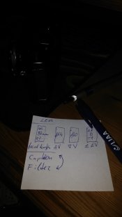
Something like in the attachment. Filter should go straight under the Lens setting though. And under the three dots thingy there could be the option to change frame number, date, etc.
This approach would dramatically reduce step count and clutter. And adjustments between shots could be made much faster.
Aaand map is great too! But maybe the labels could not only show Frame No. and date, but Notes too, and/or be a link to a specific entry? And be exportable as a map to Google My Maps
Aaaaaaaaand maybe film rolls Notes could show up in Lightroom Caption and Flickr Description too, to populate something like:
"Film + Developer + Push/Pull/Shot at different ISO + Scanner + Frame-specific notes" which would translate to something like:
"Ilford Delta 100 shot at ISO 400 and reversed in Ilford PQ Universal and scanned with Plustek OpticFilm 7600i Ai.
A nice summer breeze that smells a little of my childhood"
//Sorry if overwhelming
And one more thing - when I open .txt, there's no support for diacritics. Therefore my notes are displayed incorrectly. For example - these letters of my mother's language (Latvian) are displayed without diacritics. ĀČĒĪĻŅŠŪŽ are displayed just as ACELNSUZ. Summoning instantly a horde of Grammar Nazi demons : D
Should be saved to support international characters
EDIT: Another one.
Aperture is more of a priority (first automatic cameras had aperture priority), so usually it's a parameter that gets defined first. So it's unusual that here it's second
Oh, and Exposure compensation should probably be reset too when advancing a frame
Aaaand Aperture, Shutter and Exposure Compensation scroll-wheels maybe should be accessed straight away, not via a tap. Like a neat slot machine of three parameters
Less work to do and faster getting to take another shot.
Something like in the attachment. Filter should go straight under the Lens setting though. And under the three dots thingy there could be the option to change frame number, date, etc.
This approach would dramatically reduce step count and clutter. And adjustments between shots could be made much faster.
Aaand map is great too! But maybe the labels could not only show Frame No. and date, but Notes too, and/or be a link to a specific entry? And be exportable as a map to Google My Maps
Aaaaaaaaand maybe film rolls Notes could show up in Lightroom Caption and Flickr Description too, to populate something like:
"Film + Developer + Push/Pull/Shot at different ISO + Scanner + Frame-specific notes" which would translate to something like:
"Ilford Delta 100 shot at ISO 400 and reversed in Ilford PQ Universal and scanned with Plustek OpticFilm 7600i Ai.
A nice summer breeze that smells a little of my childhood"
//Sorry if overwhelming
Attachments
Last edited:
Ivo Stunga
Member
And about those file-names. Maybe one could scan them as 01 02 03, etc. and app could generate CMD command to rename file after schema defined in the app?
Aaaaand (lol) - maybe in the Frame list app could show name of a area where shot was taken? Say, Country and City/Parish/whatnot - in the same row as date and time? Then it would be easy to navigate and find something shot in the specific geographical area. And maybe it could be sortable too? Say, sort every photos taken in "Kaisaniemi, Helsinki, Finland" or Vecrīga, Rīga, Latvija : ) Oh, nevermind - such a sorting is already in the Map section. But to display that location in Frame list would be nice though.
I'll calm my tits and will shut-up for a moment now : D
Last edited:
OP
OP
Haha, wow, that's a lot suggestions. Thanks so much! I'll definitely add them to my list, but it's going to take some time to work through them all though. I usually dedicate a few hours of each weekend (and some random nights in the middle of the week) to develop this app. So sadly any changes won't happen very quickly.
Putting the scroll wheels behind separate buttons was a conscious choice. When there are too many scroll wheels on one window, it's really easy to scroll them, when instead you want to scroll the entire window. I hope my explanation makes sense. But as I said, I'm going to work on the app's UI next, so hopefully it will become much more intuitive and informative.
Thanks so much! I'll definitely add them to my list, but it's going to take some time to work through them all though. I usually dedicate a few hours of each weekend (and some random nights in the middle of the week) to develop this app. So sadly any changes won't happen very quickly.Putting the scroll wheels behind separate buttons was a conscious choice. When there are too many scroll wheels on one window, it's really easy to scroll them, when instead you want to scroll the entire window. I hope my explanation makes sense. But as I said, I'm going to work on the app's UI next, so hopefully it will become much more intuitive and informative.
Ivo Stunga
Member
It makes complete sense. Will be waiting eagerly
OP
OP
Hey everyone! I just uploaded v1.8.0 to the Play Store. Changes include:
- Bug fixes
- UI updates
- Frames can be edited from the map
- Map shows more information about frames
- Frame can have multiple filters
- Support for diacritics and umlauts in ExifTool commands
- Display formatted address for location along with coordinates
- Adding a complementary picture to a frame with the phone's camera
Ivo Stunga
Member
Ho-ho-ho, things are quite in movement - appreciated! And it's nice seeing user input being taken into account.
I'm all about the speed - to write down data ASAP, and return to taking some more pics.
About the fields presented as a list - I don't know. Data input speed-wise hadn't changed a lot. Clutter-wise - yes, this seems to be more visible, so to say.
Scroll-wheels without the need to click on them to activate input would be probably the fastest way to input data. But, as you said, if it's messing with the ability to scroll whole screen - no good. Unless there's a way to make everything in one un-scrollable screen (as I drew before, for example).
Vertical window size could be further reduced by hiding Frame Count, Date and Time, Location settings under the options button (say - stacked dots in the same row as the window description "Add new frame", in Top Right corner), as these parameters don't need to be edited for every frame, every time. If such a need arises - press the stacked dots, and Voila - edit those fields! That would reduce the clutter even further, simplifying UI.
So - in essence - I'm for UI that gets the shit done ASAP. If there's no faster way than this - great! : )
And I love what's being done on the Map side too - superb! My compliments!
But it could use Hybrid/Sattelite view too - as it tends to make it easier to correct location when you can see buildings for reference. So - maybe an option to switch between Map modes?
Waiting for diacritics though : )
Ivo Stunga
Member
I encountered some bugs while trying to edit description and/or add new filter from the New Frame window. Bug results in data not being saved, which is not fun at all : )
Have sent a bug-report to your mail.
Have sent a bug-report to your mail.
OP
OP
I encountered some bugs while trying to edit description and/or add new filter from the New Frame window. Bug results in data not being saved, which is not fun at all : )
Have sent a bug-report to your mail.
Thanks for the heads up! I've released a hotfix version (v1.8.1) to the Play Store. This should fix the problem with the keyboard covering the frame edit window. Please let me know how it works out.
I have basically two phones that I use to test the app: Samsung Galaxy Note 3 (Android 5.0) and OnePlus 3 (7.1.1). I run a few emulators too, but none of these produced the bug quite as badly as it did with you. Sometimes the keyboard would be left visible behind the windows (not obstructing the OK and Cancel buttons), but usually it worked ok.
And to make matters more weird, I simply couldn't get rid of the bug without making some minor UI tweaks. So now the notes are edited straight from the frame edit window. I might have been able to make it work without changing the UI if I had more time, but I thought a quick fix would be best.
A lengthier explanation for the technically inclined: the bug was caused by the fact that the frame edit window didn't contain (it does now) any text input elements. So when the user closes the note edit window, there are no input elements for Android to focus on, and this results in weird keyboard behaviour. Generally in Android the framework around controlling the keyboard is clumsy to say the least. For example force hiding the keyboard wasn't simply possible in this case. That's my rant over.
I spent four hours today fixing one small bug.Sorry and thanks everyone for being patient. I'll try to be more careful.
Ivo Stunga
Member
No problems - your dev status anyway is Legendary for taking user input tangibly into account and responding so fast to it. Kudos!
Mick Fagan
Subscriber
I have to say a big thank you. I have downloaded this and it works a treat, although I must admit this is the first application I have downloaded to any phone and I am a bit of a Luddite when it comes to things like this.
For someone who is reasonably inept with phone usage, other than actually talking on them, I found it interesting that I could navigate through the program and eventually work out how most things are done.
My next trick, is it to figure out how to download the data, so I can print out the information to store with the contact sheets in my contact sheet boxes, or maybe to store the printed information in ring binders.
Just a question, I switched the program on as I was typing this and it came up with a confirm/cancel dialogue box about the software, mentioning v1.8.1; is this the new upgraded version you have just mentioned?
Do these kinds of updates happen automatically like this, if they are released?
Mick.
OP
OP
I have to say a big thank you. I have downloaded this and it works a treat, although I must admit this is the first application I have downloaded to any phone and I am a bit of a Luddite when it comes to things like this.
For someone who is reasonably inept with phone usage, other than actually talking on them, I found it interesting that I could navigate through the program and eventually work out how most things are done.
My next trick, is it to figure out how to download the data, so I can print out the information to store with the contact sheets in my contact sheet boxes, or maybe to store the printed information in ring binders.
Just a question, I switched the program on as I was typing this and it came up with a confirm/cancel dialogue box about the software, mentioning v1.8.1; is this the new upgraded version you have just mentioned?
Do these kinds of updates happen automatically like this, if they are released?
Mick.
Hi Mick, and thanks for the feedback! Glad you find the app useful. The objective is to keep the app as intuitive as possible while adding new features at the same time.
If you want to print the information to store with your negatives, I recommend using the app's csv file export. This allows you to export a roll's information in csv file format which you can then edit and print on your computer using a spreadsheet programme like Excel, Numbers etc.
And to answer your questions. After every update when the app is first launched, a window describing the current version code and latest changes is shown. New features, changes in the app's functionalities and other important information are listed here. The same information can be found later when clicking on the ellipsis on the top right corner of the screen and then clicking 'About'.
If the window appeared on its own, then I would assume you have automatic app updates enabled. This option is configured in the Play Store's settings, so I have no control over it. So in other words, yes, in your case the app will automatically update when I release new versions to the Play Store.
I hope this helps.
-Tommi
Mick Fagan
Subscriber
Tommi, once again, many thanks.
I now know what a vertical Ellipsis is, thanks to Wikipedia.
I will endeavour to follow your instructions for exporting the data in a way I can use at the moment, with an added bonus that one day I may be able to add this information electronically to an electronic version of one of my negatives. I won't be holding my breath though.
I found play store again (don't laugh) yep, auto update was selected whenever Wi-Fi was available, turned that off.
I shot a roll in pouring rain today, ducking under cover to access the phone to add information, worked a lot better than the dummy rolls I inputted while trying to learn how it all works.
Leaving for a trip to Iceland in a week, so this is perfect timing.
To say the map feature is an eye opener is a gross understatement. I was explaining to my missus one of the shots I managed to get in torrential rain and was trying to detail the place I was standing under for shelter when I took it. Eventually I did the map thing of that particular frame, it zoomed into a street level of information to give a reasonably precise area. I know it was about 1m within the exact spot, nevertheless, she thought that was pretty cool.
By the way, my phone is a Huawei GR3 it runs Lollipop (Android 5.1)
I have been taking quite meticulous notes for all of my 4x5" sheet film exposures, I have a pile of notebooks originally all in pencil, then I switched over to a Space Pen with the ability to write underwater, since then I have used ink for my film exposure notebook write ups. I think I may switch over to this mobile phone application for my 4x5" work, in the not too distant future. I didn't know my phone had a GPS facility until I started using this programme; always learning something.
Mick.
OP
OP
Tommi, once again, many thanks.
I now know what a vertical Ellipsis is, thanks to Wikipedia.
I will endeavour to follow your instructions for exporting the data in a way I can use at the moment, with an added bonus that one day I may be able to add this information electronically to an electronic version of one of my negatives. I won't be holding my breath though.
I found play store again (don't laugh) yep, auto update was selected whenever Wi-Fi was available, turned that off.
I shot a roll in pouring rain today, ducking under cover to access the phone to add information, worked a lot better than the dummy rolls I inputted while trying to learn how it all works.
Leaving for a trip to Iceland in a week, so this is perfect timing.
To say the map feature is an eye opener is a gross understatement. I was explaining to my missus one of the shots I managed to get in torrential rain and was trying to detail the place I was standing under for shelter when I took it. Eventually I did the map thing of that particular frame, it zoomed into a street level of information to give a reasonably precise area. I know it was about 1m within the exact spot, nevertheless, she thought that was pretty cool.
By the way, my phone is a Huawei GR3 it runs Lollipop (Android 5.1)
I have been taking quite meticulous notes for all of my 4x5" sheet film exposures, I have a pile of notebooks originally all in pencil, then I switched over to a Space Pen with the ability to write underwater, since then I have used ink for my film exposure notebook write ups. I think I may switch over to this mobile phone application for my 4x5" work, in the not too distant future. I didn't know my phone had a GPS facility until I started using this programme; always learning something.
Mick.
Wow, I'm actually going to Iceland in about a week as well. What a coincidence. Have a nice trip! I'm sure you'll get some stunning photos.
-Tommi
Mick Fagan
Subscriber
Wow, I'm actually going to Iceland in about a week as well. What a coincidence. Have a nice trip! I'm sure you'll get some stunning photos.
-Tommi
What a small world. If you see someone running around with an F3, it's a good chance that will be me. We'll be there for 1½ months, so one never knows.
On another note, pun intended. We had dinner with someone last night who does a fair bit of travelling, this application of yours came up. She was really interested in the map locating feature of your program. Her desire was to allow her to quickly put in a point reference of her (in phone) notes she writes as she is travelling. As in; while standing at a location, she would be able to write into her notes, "what a great place to meet up with so and so" at which point she would invoke the map location part of your program, then continue walking. She would then be able to text, email, or whatever, that piece of text with the location reference embedded to anyone she wished to either share with, or meet up with, at that location.
Another thought she had, was, it would a tremendous way to send her location, in a map sense, to someone else walking in the same city so they could find her by using the map information she had just texted. As someone who has done a fair bit of walking around European city scapes, I recognise this as a nice possibility.
I thought that was an interesting observation of what she saw in your application that would be immediately useful to her, not sure if anything like that is available.
Mick.
Mick Fagan
Subscriber
Well I have successfully exposed a roll of film in reasonably bad weather, which, apart from the lack of cold, should simulate conditions rain wise, of the upcoming Iceland trip.
I really was surprised at how easy it was to shoot, then enter the data onto the phone, then shoot again and so on.
The roll was developed, cut up and looked at carefully with a loupe, one very nice frame stood out by a long shot, with perhaps another 5-6 frames being worthy of further exploration. However as this was really an attempt to see if the lenses I have chosen would do the job on the trip, as well as be workable in rainy weather, I didn't discriminate like I would when overseas and with finite film at my disposal.
I then worked through the export regime that Tommi suggested; in fact it was easy as anything as I exported the suggested file via email to myself, then opened one of the exported files in a spreadsheet.
A bit of fiddling as I am not really a spreadsheet person, along with a huge input from the missus and I was really impressed with what I had.
I ended up with a landscape printed, A4 single page, of a full 36 frame roll of film with all of the data. This will be filed along with the film itself. Another print out will be filed in a ring binder folder for easy as anything foolproof filing, which doesn't require a computer.
I have showed this output to a few people and pretty much they all said was, "where did you get this App from"?
Attached is an image of most of the stuff you get, the bottom frames are missing as the screen shot I took didn't have everything. The only changes I have made are the push/pull: where I added this information in the spreadsheet, even though with hindsight, I knew I was going to give the roll a kick to add contrast to a flat wet day. There are also a couple of bits of deliberate covering of sensitive data.
Tommi, this is a brilliant tool for filing, recording rolls and rolls of film as one goes on a holiday, or in just everyday life; I really do thank you for this program.
Mick.
OP
OP
That's great, Mick! I'm glad the app works for your needs.
In fact, the initial purpose of this app was to allow me to save some information in spreadsheet format along with my scanned negatives. So your use case is pretty much what I had in mind just over two years ago when I started developing this app. The ability to tag scanned files' EXIF data came later on as a side project. Actually, had it not been for ExifTool by Phil Harvey, I probably wouldn't have even tried to incorporate such a feature.
For the past few days I've been taking some time off from writing (too much) code in my spare time. But I'm hoping to soon add new useful features, such as formatted address along with coordinates as well as support for diacritics. So stay tuned!
Valerie
Subscriber
This looks fantastic! Am downloading now and have also shared with my film students!
OP
OP
Okay everyone, I've uploaded version 1.9.1 to Play Store this morning. It includes some long awaited features:
- Frame can now have a formatted address. If no address is found, coordinates are displayed instead.
- Support for diacritics in ExifTool commands
- Map type (normal, satellite etc.) can be changed whenever map is shown
Mick Fagan
Subscriber
Tommi, I have just downloaded the latest version, very impressive address features.
I wasn't aware whether or not the map formatting could be changed in the other version I had, but the changes one can now make, have enhanced that feature greatly. All of my addresses in the remaining rolls of film still in the program on my phone, have changed to a street address, very cool. One of the addresses I checked was incorrect (house number) but a zoom in and a tap and the correct address is now there.
If you see an old grey/white haired/bearded fella running round with a Nikon F3 in Iceland, that's me. Introduce yourself and I'll buy you a hot chocolate, or whatever takes your fancy.
Mick.
OP
OP
Tommi, I have just downloaded the latest version, very impressive address features.
I wasn't aware whether or not the map formatting could be changed in the other version I had, but the changes one can now make, have enhanced that feature greatly. All of my addresses in the remaining rolls of film still in the program on my phone, have changed to a street address, very cool. One of the addresses I checked was incorrect (house number) but a zoom in and a tap and the correct address is now there.
If you see an old grey/white haired/bearded fella running round with a Nikon F3 in Iceland, that's me. Introduce yourself and I'll buy you a hot chocolate, or whatever takes your fancy.
Mick.
Haha, I will definitely keep an eye out for a man with that description. I'll be sure to come say hi.
-Tommi
| Photrio.com contains affiliate links to products. We may receive a commission for purchases made through these links. To read our full affiliate disclosure statement please click Here. |
PHOTRIO PARTNERS EQUALLY FUNDING OUR COMMUNITY:  |