- Joined
- Jul 14, 2011
- Messages
- 15,218
- Format
- 8x10 Format
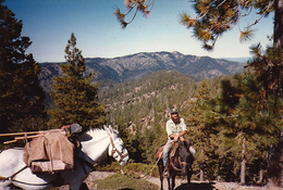
Nobody can get in right now due to all the snow and dangerous runoff. The Middle Fork of the Kings is the deepest canyon on the continent. The South Fork, where the road ends and trails begin, is slightly less deep and far more negotiable to hikers. Quite a few areas are rarely visited. Some remote lakes might not have ever seen a human visitor. That's the way it should be. Only the Rae Lakes loop and John Muir/PCT trail get a lot of foot traffic. But two critical bridges have washed out, and certain approach highways are still a mess, and might not open at all this year; so it might be an especially quiet season deeper in.
The notion of even attempting to build any kind of road past "Roads End" in Cedar Grove would be an engineering absurdity. The more pressing need for having such areas officially preserved was to prevent any more dams in our splendid glacial canyons, as well as end destruction of high meadows from sheep and cattle. There are still plenty of open range grazing opportunities at lower less sensitive elevations. There was also the need to limit logging in what is now adjacent Sequoia NP and Sequoia NF. The biggest trees on earth were being felled to acquire a lumber too brittle for any other usage than shingles and fruit crates. And now, about 20% of the remaining groves perished in the massive fire two years ago. Nothing like that is evident in the past history of these groves, within the three or four thousand years of detectable record in their growth rings. Most of the ancient trees wear scars of ground fires over the centuries, but their bark is very thick and fire resistant. But now a kind of fire has arrived with flames so high and intense that they burned many trees from the crown down, and spread tree to tree in that manner. And these giant sequoias are very tall trees themselves. That should certainly be a wake-up call that the climate is no longer as usual.
Where you evidently hiked was affected by an extreme fire about a decade ago, but much further down the ridge westward. Nothing above timberline, or even beyond the entrance to Cedar Grove burned. But historic structures where the winding road down into there first reaches the River itself were wiped out, along with brushy hillsides both north and south, clear over to the edge of the North Fork of the Kings at mid elevations. Big cyclic fires occur in the brush naturally, especially due to lighting, in about 40 year cycles. The last relatively natural one was in the 1960's. But even that was tiny compared to the one a decade ago.
A remarkable incident occurred during that big fire. A woman in her early 70's was with a group backpacking a section of the North Fork of the Kings. She got disoriented by the smoke, separated from her company, and took a wrong turn that led into a remote basin, where she stumbled into a ravine and broke her hip. It's a big area, and even search parties and helicopters couldn't see much of anything due to constant smoke. She only had a little daypack with a sweater in it, but heard a trickle of water, and spent two days crawling on her belly to get to it. There she stayed, eating ants and bugs and grass for another ten days, until she was finally spotted. She was taken out by helicopter and made a fully recovery.
Last edited: