-
Welcome to Photrio!Registration is fast and free. Join today to unlock search, see fewer ads, and access all forum features.Click here to sign up
- Home
- Forums
- General Discussion (Mixed Workflow Forums)
- Photographic Aesthetics and Composition
- Landscape
You are using an out of date browser. It may not display this or other websites correctly.
You should upgrade or use an alternative browser.
You should upgrade or use an alternative browser.
Post your landscape photos here
-
- Thread starter Sirius Glass
- Start date


Recent Classifieds
-
For Sale FS: Fujinon 250mm f/6.7 Lens
- Started by B.S.Kumar
-
For Sale Kodak Ektachrome Infrared EIR aka Aerochrome
- Started by YoIaMoNwater
-
Want to Buy Old Kodak 101 roll film
- Started by blee1996
-
For Sale Schneider Kreuznach Super Angulon MC 120mm f8
- Started by RoboRepublic
-
Sold JOBO MultiTank 2 2521 4 X 5
- Started by Inayat Noor
Forum statistics
Astia 100fView attachment 417870
Nice light.
Nice light.
Thank you, Stephen/
Where is this place?
Astia 100fView attachment 417870
Very pretty. What aspect ratio are you using?
Very pretty. What aspect ratio are you using?
6x12 Horseman rollfilm adapter for 4x5 camera
Very beautiful, peaceful sceneAstia 100fView attachment 417870
Very beautiful, peaceful scene
Thank you Jon!
Where is this place?
Do you ask me? This shot I've got at Kaluga region 300 km from Moscow.
Last edited:
Pentax 67, 90mm f2.8 unfiltered
RVP50, multispot/MWA metered
Cropped to 6x6.
In private collection.
__________________________________________________
'Evening at the Taoist Tree',
Lake Bonney, Barmera Riverland, South Australia,
December 2017
© Silent Street Photography AUS
View attachment 203830
I love the colour and composition of this lovely image,
Tumbles
Member
Pentax LX + Sigma 20 f1.8 lens
Provia 100F
During the 2019 wildfires in California.
.jpg")
Provia 100F
During the 2019 wildfires in California.
Alan Townsend
Member
Here are two shots from fall 2025 both on Kentmere 100 processed in MC-glycerol 1:100 12 min., taken with Minolta srt-101 and Tamron 28-200 zoom at 28mm, F11@1/8th sec., orange filter. Both are phone scans of negatives adjusted only for brightness and contrast. Color is due to my method of scanning, to simulate brown tones that I like. These negatives a very thin, with density range of 1.2 due to errors in using measuring syringe. Both taken at Robinson Park, Peoria, IL, a 630 acre wilderness area formed by an ancient flood that occurred 10,000 years ago when a huge glacial lake escaped its retaining and formed the entire Illinois River bed overnight.


An evocative image - I guess at the moment, you'd need a sled and a team of huskies to get in there now!
Here are two shots from fall 2025 both on Kentmere 100 processed in MC-glycerol 1:100 12 min., taken with Minolta srt-101 and Tamron 28-200 zoom at 28mm, F11@1/8th sec., orange filter. Both are phone scans of negatives adjusted only for brightness and contrast. Color is due to my method of scanning, to simulate brown tones that I like. These negatives a very thin, with density range of 1.2 due to errors in using measuring syringe. Both taken at Robinson Park, Peoria, IL, a 630 acre wilderness area formed by an ancient flood that occurred 10,000 years ago when a huge glacial lake escaped its retaining and formed the entire Illinois River bed overnight.
View attachment 418921
View attachment 418922
I like the composition a lot - two diagonal slopes stabilised by verticals. Nice.
An evocative image - I guess at the moment, you'd need a sled and a team of huskies to get in there now!
Thanks for the kind words, but with respect to the climate conditions, not in this corner of North America.
We have palm trees in the median of our main street.
The current weather here - nice sunny day, comfortable if you have a mid-weight to light coat on:
7C = ~44F = a nice February day.
The Vancouver regional area is looking at the possibility of having the first snow free winter in decades, but even during colder winters, snowy days are infrequent in our corner of it.
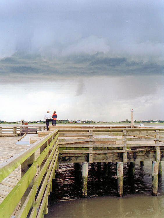
As you show your location as Delta BC Canada, I thought you'd be under snow, as it has been shown on our tv news. But 7C at 1600hrs in our neck of the woods would have us all in woolies. It's just gone noon here in Rural NE Victoria with the temp' sitting at 27C. Anything below 20C and we all start wearing our long johns! Of course it's the 25th here downunder and here's what we're looking at for the next two days - I'm not cool enough to screenshot a neat meteorological chart. 

Cheers,
Wednesday 25 February
Cloudy. High chance of showers, becoming less likely in the afternoon. The chance of a thunderstorm, possibly severe with heavy rain which may lead to flash flooding. Winds S/SE 15 to 25 km/h.Thursday 26 February
Cloudy. Medium chance of showers, most likely in the morning and afternoon. The chance of a thunderstorm in the afternoon and evening. Winds SE 15 to 20 km/h becoming light in the early morning then becoming E/SE 15 to 20 km/h in the evening. The map shows the route I drove in 2009. I live near the border to NSW, defined by the River Murray (dotted line)
Cheers,
Last edited:
But 7C at 1600hrs in our neck of the woods would have us all in woolies.
It is true that only the more hardy of the folks around here are in shorts
 .
.This area is on of the most temperate in North America - not too hot, and not too cold.
This is from early summer, and seems to fit with the spirit of this thread:
Summer? Sky
- MattKing
- 5
Last Sunday was the first Sunday of summer here. It's hard to tell, isn't it?
All comments...
All comments...
@MattKing
I see by the map that you live more or less on the edge of the Northern Pacific - hence your temperate climate. By comparison, where I live is in the hinterland more than 300kms from the sea. That is hard on an expat Tasmanian who loved watching the Sydney-Hobart Yachts sail up the Derwent, soon after leaving Sydney on Boxing Day each year.
Wild Oats takes line honours 30/12/2007, four days after leaving Sydney. I don't recall if there were any Candian entries, or indeed if there ever are.
Last edited:
bags27
Member
I love what you did with these. Terrific.Here are two shots from fall 2025 both on Kentmere 100 processed in MC-glycerol 1:100 12 min., taken with Minolta srt-101 and Tamron 28-200 zoom at 28mm, F11@1/8th sec., orange filter. Both are phone scans of negatives adjusted only for brightness and contrast. Color is due to my method of scanning, to simulate brown tones that I like. These negatives a very thin, with density range of 1.2 due to errors in using measuring syringe. Both taken at Robinson Park, Peoria, IL, a 630 acre wilderness area formed by an ancient flood that occurred 10,000 years ago when a huge glacial lake escaped its retaining and formed the entire Illinois River bed overnight.
View attachment 418921
View attachment 418922
- mayelbarads
- Deleted
@MattKing
I see by the map that you live more or less on the edge of the Northern Pacific - hence your temperate climate. By comparison, where I live is in the hinterland more than 300kms from the sea. That is hard on an expat Tasmanian who loved watching the Sydney-Hobart Yachts sail up the Derwent, soon after leaving Sydney on Boxing Day each year.
Wild Oats takes line honours 30/12/2007, four days after leaving Sydney. I don't recall if there were any Candian entries, or indeed if there ever are.
View attachment 418956
I don't know about the Wild Oats events, but I have friends that have sailed in really demanding races down your way.
Our sailing community is energetic.
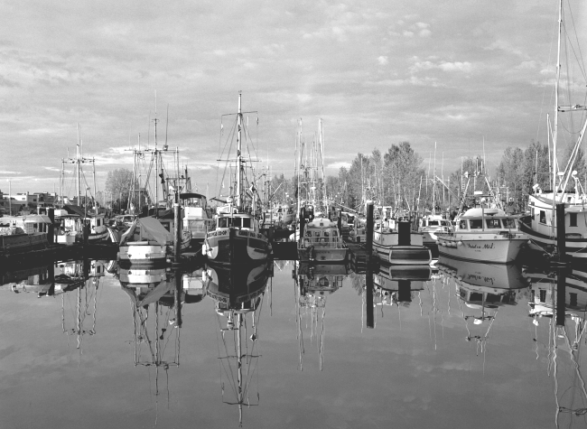
This was a short walk from our old place - more work boats than pleasure, and more power than sail in this case.
The Swiftsure is probably our best known local sailing event.
Boats at Rest
- MattKing
- 2
A quiet morning near my home. Given all the detail, I think this might only succeed if it is...
It's many a year since I shot with a MF film camera - I can see how your orange filter has effectively acted like an ND filter on a digital camera to produce such a pleasing image.
"Money - money - money - it's a rich mans world! @abba" I was in the wrong business!

Presumably your photo was taken somewhere near your place in that waterway that opens into the ocean - I saw on the map of Delta. It isn't named on the map I saw, what is it called?I don't know about the Wild Oats events, but I have friends that have sailed in really demanding races down your way.
Our sailing community is energetic.
This was a short walk from our old place - more work boats than pleasure, and more power than sail in this case.
The Swiftsure is probably our best known local sailing event.
Boats at Rest
- MattKing
- 2
A quiet morning near my home. Given all the detail, I think this might only succeed if it is...
"Money - money - money - it's a rich mans world! @abba" I was in the wrong business!
Presumably your photo was taken somewhere near your place in that waterway that opens into the ocean - I saw on the map of Delta. It isn't named on the map I saw, what is it called?
In that location it is a side tributary of the Fraser River close to where it drains into where the Georgia Straight and the Juan De Fuca straits meet and comingle.
In that location it is a side tributary of the Fraser River close to where it drains into where the Georgia Straight and the Juan De Fuca straits meet and comingle.
Thanks Matt. That explains how Delta got its name.
Very nice, Igor.
| Photrio.com contains affiliate links to products. We may receive a commission for purchases made through these links. To read our full affiliate disclosure statement please click Here. |
PHOTRIO PARTNERS EQUALLY FUNDING OUR COMMUNITY:  |