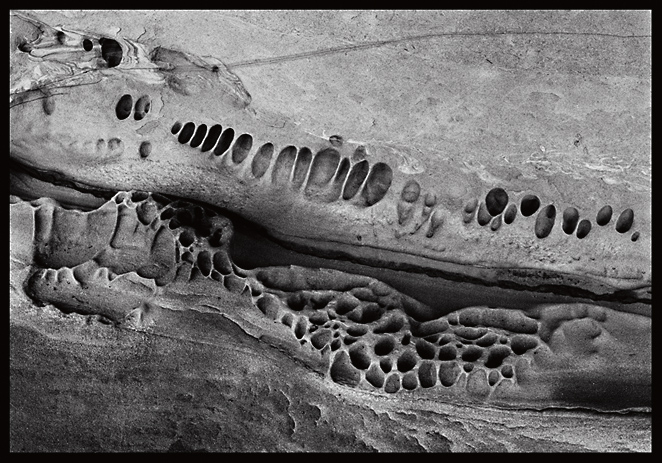
ScuplturedCoast#1

ScuplturedCoast#1

12X17 Carbon Transfer Print

Place -- Gulf Islands, BC
Format -- 5X7 Nagaoka
Lens -- 125 Fujinon SWD
Film -- Kodak TMY (TMAX-400)
Exposure -- 3:00 at f/32
BTZS data -- SBR 6
Development -- Pyrocat-HD 1.5:1:200, 40 minutes at 70ºF, minimal agitation.

Thanks for your comments.

Sandy King
Location
Gulf Islands, BC
Equipment Used
5X7 Nagaoka
Exposure
3:00 at f/32
Film & Developer
TMY, Pyrocat-HD
Paper & Developer
Carbon Transfer Print
Lens Filter
None
I like this a lot - when I try to to this sort of thing, my negatives come out so much smaller than yours :smile:.

Which Gulf Island is this, and when were you up our way?

Matt
 
Hi Matt,

What size camera are you using? 35mm tends to come out a lot smaller than 5X7!!

The island is Gabriola.

Spent a couple of weeks there last summer. If all goes well hope to be back there again this year in June or July. I have a good friend (from California by way of Oaxaca, Mexico) who lives there from April through October.

Sandy
 
Hi Sandy:

It is a small world indeed.

My wife and I have holidayed on Gabriola for each of the last two years, and have another trip scheduled for this coming September.

Most of my shots there are on 6x4.5, but I have a printing backlog of the B & W negatives, and my MF scanner has been out of commission since last fall for the transparencies.

It's a great Island - photographically and otherwise.

If you are in the Vancouver area at either end of your trip, you should consider contacting me ahead of time - to see if we can set something up. Us "Kings" need to stick together, you know :smile:.

Matt
 
Hi Matt,

Let's exchange contact information and see if we can get together. My email is sanking@clemson.edu.

I sure hate that you let it get out what a great place this is for photography! My fault I guess for posting the image.

Sandy
 
Sandy:

You are absolutely right.

Everyone on APUG - I was wrong - you won't like it there. You shouldn't bother going.

:smile:

Matt
 
Fascinating picture. I'm not sure what we're looking at, though. Is this the side of a sandy sea cliff? Or is that a beach/ground area?

Whatever it is, it's beautiful to look at.
 
Hi Pat,

The image is both. It is the side of an eroded cliff, sort of an alcove, and it is also adjacent to a beach/ground area. The textured subjects you see are most likely caused by water erosion, though how I am not sure since the area is quite above normal sea level and not subject to intrusion from water from rain fall-off.

Best,

Sandy
 
Hi all,

This phenomenon is called "honeycomb weathering" and it occurs in all sorts of different rock types throughout the geological record on Earth and perhaps also on other planets, such as Mars. It's origin is not fully understood but it appears that it is a complex combination of both chemical and physical processes ultimately generating small cavities which grow to a certain point and then stop.

Experimental work indicates that salt crystallization in pore space is quite important in initiating small fractures/cavities.

The eroded cliff in Sandy's picture was buried a few hundred thousands or million years back in time and thus subject to sub-surface fluid circulation.

Here are some relevant articles:

http://www.nature.com/nature/journal/v298/n5870/abs/298121a0.html

http://bulletin.geoscienceworld.org/cgi/content/abstract/111/8/1250

http://adsabs.harvard.edu/abs/1998GeoRL..25.3249R

If you google "honeycomb weathering", you will come across a suite of websites with photographs.

Best,

Markus
 
Here's a simple explanation regarding the geology of the Gulf Islands:

The Upper Nanaimo Group is a succession of siliciclastic marginal-marine and marine sediments in southwestern British Columbia. On the north tip of the Saanich Peninsula and several small, adjacent islands, the lowest 3 formations of the Nanaimo group are exposed. The basal unconformity is overlain by Comox Formation conglomerates and sandstones representing deposition along a high-relief, storm-swept shoreline open to the proto-Pacific Ocean. Fan-delta, strandplain-shoreface, and barrier-island complex deposits are preserved within this formation. The Haslam and Extension formations, representing mudstone-sandstone turbidites and conglomerate-sandstone submarine channel fills respectively, overlay the Comox Formation. The depositional history suggests slow, persistent transgression within a peripheral foreland basin, with sediment supplied by contemporaneous thrusts to the east. Nanaimo Group strata have been affected by at least two major deformation events. Evidence from the Eocene Cowichan Fold and Thrust System and the Neogene Gulf Island Thrust System is preserved within the study area.

Clear as mud, yes? ;~)
 

Media information

Category
Standard Gallery
Added by
sanking
Date added
View count
1,054
Comment count
11
Rating
0.00 star(s) 0 ratings

Image metadata

Filename
scuptedcoast1.jpg
File size
235.1 KB
Date taken
Tue, 13 February 2007 8:15 PM
Dimensions
662px x 463px

Share this media

Photrio.com contains affiliate links to products. We may receive a commission for purchases made through these links.
To read our full affiliate disclosure statement please click Here.

PHOTRIO PARTNERS EQUALLY FUNDING OUR COMMUNITY:


Ilford ADOX Freestyle Photographic Stearman Press Weldon Color Lab Blue Moon Camera & Machine
Top Bottom